These icons are designed to help you quickly understand and learn important information about our products.
Teaching Method
Traditional
Teacher-centered curriculum commonly used in classrooms that may include a text, teacher manual, tests, etc.
Charlotte Mason
A methodology based on the work of a 19th century educator who maintained that children learn best from literature (Living Books), not textbooks.
Classical
A methodology based on the Latin Trivium (three stages of learning), including the grammar stage (memorization and facts), logic stage (critical thinking), and rhetoric stage (developing/defending ideas).
Unit Study
A thematic or topical approach centered around one topic that integrates multiple subject areas.
Montessori (Discovery)
A methodology based on the work of a 20th century educator that emphasizes student and sensory-driven discovery learning and real-life applications.
Other
Other methodologies
Religious Content
Secular
Contains content contrary to common Christian beliefs (i.e. evolution).
Neutral
Avoids religious or theoretical topics or presents multiple viewpoints without preference.
Christian/Religious
Faith-based or including instructional religious content.
Learning Modality
Auditory
Learns through listening, talking out loud or reading out loud.
Visual
Learns through seeing, prefers written instructions and visual materials.
Kinesthetic/Tactile (Hands-On)
Learns through moving, doing and touching.
Multi-Sensory
Curriculum that employ a variety of activities/components.
Presentation
Sequential
Curriculum progresses through well-defined learning objectives. Emphasizes mastery before moving to the next topic.
Spiral
Topics and concepts are repeated from level to level, adding more depth at each pass and connecting with review.
Conceptual/Topical
Focus is on the “why,” often with a unifying concept as well as specific skills; coverage may be broader.
Teacher Involvement
Low Teacher Involvement
Student-led materials; parent acts as a facilitator.
Medium Teacher Involvement
A mix of teacher-led time and independent student work.
High Teacher Involvement
Teacher-led lessons; may utilize discussions, hands-on activities and working together.
Additional Materials Required
No other materials needed
Everything you need is included.
Other Materials Required
There are additional required resources that are a separate purchase.
Other Materials Optional
There are additional resources mentioned or recommended but are not absolutely necessary.
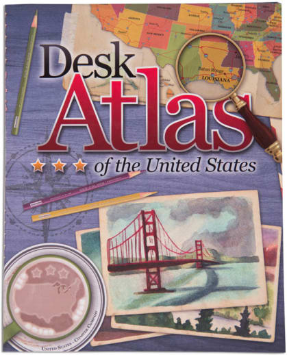
Any description of this atlas has to include a suggestion to view the sample pages online. After all, a picture is worth 1000 words! Looking at this atlas is a visual (and informational) treat. Each state (and Washington D.C.) covers a two-page spread. It has the appearance of looking like a desk blotter; with a journal open showing a map and a brief overview of the state. Surrounding the map are notes, dates, facts, illustrations and trivia "paper clipped" or "taped" in place. Readers are introduced to all of the basics: state birds, flowers, seals, flags, statistics, quarters, events, people, and much more. The maps are topographical with major cities and Interstate highways marked. Thematic maps show farm resources, expansion, population, climate and regions; and the paperback atlas ends with a state almanac and a list of geography terms defined. NOTE: there is an error on the Oregon page in reference to the zoo. Zach
Publisher's Description of Desk Atlas of the United States
The Desk Atlas of the United States is an intriguing book of maps, history, facts and symbols of each of the 50 American States.
Information for each state includes:
Summary of Climate, Geography and Features
State Quarters, Flags and Seals
Date of Statehood, Mottos and Symbols
Beautiful Physical Maps
Favorite Tourist Destinations
Features on Significant Historical Events and People
Timeline of Key Events
And Much More!
Large (9.625" x 12") full-color immersive design will inspire kids to explore our great nation.
Following the same format as Trail Guide to World
Geography, this guide offers a variety of options to add a little U.S.
geography to your curriculum. The thirty-six weekly lessons in this book cover the fifty states, organized by region. Students study the states at a rate of about two per week. This easy-to-teach book covers essential geographical facts and features of each state. There are three types of assignments: Geography
Trails, Points of Interest Mapping and Points of Interest Trail Blazing. Each
week contains four days of the Trails, which are questions that the student
uses the Desk Atlas of the U.S. to answer. These usually take about 5
minutes to answer. Points of Interest Mapping activities ask the student to
draw and label points of interest on an outline map. Trail Blazing assignments
require students to research and write about various state-related topics in
their state notebook. The book wraps up with a literature unit on the Lewis and
Clark expedition, using the book The Captain’s Dog. You will need either Uncle
Josh’s Outline Maps or the Notebook; both will include the outline maps needed.
Digital download versions are also available.