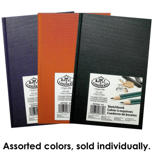
"Bargain Books" are brand new items that have minor physical blemishes due to shipping or handling that do not affect the use of the item. All Bargain Books are sold as is and all sales are final (no returns, exchanges or cancellations). Bargain books will remain in shopping cart for up to 12 hours and will then be removed if order is not completed. Orders consisting of regular and Bargain items can be purchased by credit card or PayPal and are shipped together (with two packing slips).
This item is a digital download file and is not a printed or physical product. Upon completion of checkout, you will receive an email with a link for you to download the file and save to your local device. Please note that ebooks and other digital media downloads are not returnable and all sales are final.
An excellent companion to Story of the World, this collection does all the legwork for you compiling accurate maps relative to the time periods taught in Story of the World. As turnkey as it gets!
I love the comprehensive nature of this curriculum. I love that I can print the maps for use in our homeschool, but also have a solid text to refer to. The decision maker was the positive reviews.
Corresponds well with Story of the World, which we use as a supplement to Classical Conversations. We found the SOTW activity book to be a bit too much, but like the map work so we're giving this a try this year.
An excellent companion to Story of the World, this collection does all the legwork for you compiling accurate maps relative to the time periods taught in Story of the World. As turnkey as it gets!
Easy resource, efficient, for making our own maps, coordinates with history. I have not yet received it but I am under the impression that it will give US maps as well.
I am looking for the ability to print out maps to use for a variety of geopolitical studies related to military operations, political disputes, type of governments, established religions, etc.
Good maps is not found in Textbooks. This seems to be the answer to learn and understand History and Geography very well. To remember places as well as physical features, students must mark them on blank maps.
I love the comprehensive nature of this curriculum. I love that I can print the maps for use in our homeschool, but also have a solid text to refer to. The decision maker was the positive reviews.
Corresponds well with Story of the World, which we use as a supplement to Classical Conversations. We found the SOTW activity book to be a bit too much, but like the map work so we're giving this a try this year.
Easy resource, efficient, for making our own maps, coordinates with history. I have not yet received it but I am under the impression that it will give US maps as well.
I am looking for the ability to print out maps to use for a variety of geopolitical studies related to military operations, political disputes, type of governments, established religions, etc.
Good maps is not found in Textbooks. This seems to be the answer to learn and understand History and Geography very well. To remember places as well as physical features, students must mark them on blank maps.
I don't have a cd player for the pdfs. Can I download them from the publisher?
A shopper
on Jun 9, 2020
BEST ANSWER:We don't currently carry them in a download version but you can check with the publisher. Its publisher, Knowledge Quest, is now a part of New Leaf Publishing.
I don't actually know. I tried to check the CD out for another person's question, and it was so slow on my laptop with a CD player that I can't answer the question...
Are all the maps printed in book? How big is the book?
A shopper
on Apr 27, 2019
BEST ANSWER:I do believe all the maps are in the book. At least, so far we have found all the maps used with the curriculum Heart of Dakota in the book. The book is about 12 inch by 9 inch and has 288 pages. The maps are outstanding, high quality printing, full color on glossy paper. We print out the student pages using the CD Rom that comes with the book. Hope this has helped!
The book has most of the maps but there are a couple that are on the CD ROM only (a blank grid for a world map, Greece map with grid, blank grid for regional maps etc., glossary). The blank maps for the students are on the CD ROM only. The book slightly bigger then 8.5*11" and it's about 3/4" thick. Hope that helps!
Yes all the maps are printed in the book. The book contains the atlas version, or "finished" version of the maps. The CD-ROM has the black outline maps that can be printed for students.The book is average sized and thinner than most hardback textbooks.
Yes all maps are printed in book and technically you could just photo copy them and use for instruction. Or print them off from CDROM. Book is large! Maybe 12 x 8
BEST ANSWER:Yes, maps of the U.S. are included. There is a current map of the entire country plus one of each individual state with it's capital, major cities, bodies of water, mountain ranges, etc. labled. There are also quite a number of historical maps of the U.S., a disproportionate number in fact, because after all the publisher is American. I would have liked to have seen more maps covering other parts of the world in the modern section, but overall it is excellent product that I am very pleased with and would recommend.
It's weird, because it includes maps of the first colonies and then individual state maps, but it doesn't have a good United States map. I've been frustrated about that.
I recommend this book with CD Rom to any Homeschool family. It was worth it to buy the complete volume and it saves a lot of time and money to have the full color Teacher's key maps in the book. Pretty much all the maps you will ever need to teach History!
Within five minutes of opening my delivery, my oldest had already settled in with the Map Trek book, a stack of tracing paper, and a pencil. He is only five, but found it easy to read and understand the maps he selected; other maps in this atlas are more complicated, of course, but he was happy to find ones he could understand. After tracing the maps, he ran into the next room to identify what he had found. I share this story as an example of how useful this resource really is because each map has a thesis, if that makes sense. We're going to use this program in conjunction with RC History, and I can hardly wait.
A "package" is made up of two or more items sold as a set, often for a reduced price. A listing of individual items that make up a package is provided on the package item's product detail page along with real-time item availability of those items. Any item sold as a package on our website is identified by a unique alpha-numeric item number (such as "APH1AB"). Although packages are sets, items are not physically bundled together.. Because most package items or components are also sold separately and may be components of multiple packages, these items may not have the same inventory availability at any point in time. When you order a package, you are charged one price for all package items. In-stock components will ship according to our normal shipping time. Any backordered components will ship separately as they become available. On your packing slip, package components are picked and packed individually and are identified with the code "PKGCMP" in the price column. The package item number is also listed at the bottom of your packing slip for reference. Please note that if your order ships in multiple boxes, package components may not all be in the same box. Package content is not flexible and cannot be modified.
Packages are returnable if all package items are returned, but individual items purchased as part of a package are returned, they may be refunded for less than the individual purchase price of that item, as they were purchased as part of a discounted package.
This is Rainbow Resource Center’s promise to you: We will not sell, rent, or give your personal information to any other organization. All information is secure inside of Rainbow. All credit card and check information is automatically deleted off of our systems once payment has been received.
Privacy policy and cookies
By browsing this site you accept cookies used to improve and personalize our services and marketing.
Read our updated privacy policy for more about what we do with your data, as well as your rights and choices - including how to manage cookies.