We use cookies to make your experience better. To comply with the new e-Privacy directive, we need to ask for your consent to set the cookies. Learn more.
World Advanced Political Laminated Rolled Map
SKU
031954
ISBN
9780762569755
Grade PK-AD
These icons are designed to help you quickly understand and learn important information about our products.
Teaching Method
Traditional
Teacher-centered curriculum commonly used in classrooms that may include a text, teacher manual, tests, etc.
Charlotte Mason
A methodology based on the work of a 19th century educator who maintained that children learn best from literature (Living Books), not textbooks.
Classical
A methodology based on the Latin Trivium (three stages of learning), including the grammar stage (memorization and facts), logic stage (critical thinking), and rhetoric stage (developing/defending ideas).
Unit Study
A thematic or topical approach centered around one topic that integrates multiple subject areas.
Montessori (Discovery)
A methodology based on the work of a 20th century educator that emphasizes student and sensory-driven discovery learning and real-life applications.
Other
Other methodologies
Religious Content
Secular
Contains content contrary to common Christian beliefs (i.e. evolution).
Neutral
Avoids religious or theoretical topics or presents multiple viewpoints without preference.
Christian/Religious
Faith-based or including instructional religious content.
Learning Modality
Auditory
Learns through listening, talking out loud or reading out loud.
Visual
Learns through seeing, prefers written instructions and visual materials.
Kinesthetic/Tactile (Hands-On)
Learns through moving, doing and touching.
Multi-Sensory
Curriculum that employ a variety of activities/components.
Presentation
Sequential
Curriculum progresses through well-defined learning objectives. Emphasizes mastery before moving to the next topic.
Spiral
Topics and concepts are repeated from level to level, adding more depth at each pass and connecting with review.
Conceptual/Topical
Focus is on the “why,” often with a unifying concept as well as specific skills; coverage may be broader.
Teacher Involvement
Low Teacher Involvement
Student-led materials; parent acts as a facilitator.
Medium Teacher Involvement
A mix of teacher-led time and independent student work.
High Teacher Involvement
Teacher-led lessons; may utilize discussions, hands-on activities and working together.
Additional Materials Required
No other materials needed
Everything you need is included.
Other Materials Required
There are additional required resources that are a separate purchase.
Other Materials Optional
There are additional resources mentioned or recommended but are not absolutely necessary.
Consumable
Consumable
Designed to be written in; not reusable.
Non-Consumable
Not designed to be written in; reusable.
Our Price
$16.99 $16.99 $13.95
Rainbow Savings: $3.04
Description
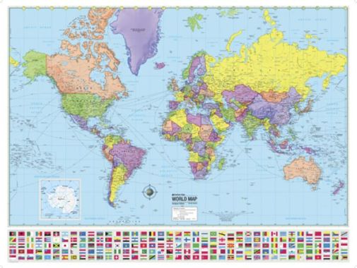
Category Description for Advanced Maps - U.S. & World (Rolled)
This map series features more detailed capital and city locations, lines of latitude and longitude, water depths and rivers, and relief shading shows mountains, deserts and wetlands. Physical World maps show ocean currents and featues a colored elevation key. The Political US map includes Indian reservations, urban areas and state flags illustrated along the bottom. The Political World Map shows time zones and International date line and country flags are also illustrated at the bottom. Each map is 48" X 36" (except for World Political Map, which is 50" x 38"). ~ Alysia
Details
| Product Format: | Other |
|---|---|
| Brand: | UniversalMap |
| Grades: | PK-AD |
| ISBN: | 9780762569755 |
| EAN/UPC: | 024327697552 |
| Length in Inches: | 48 |
| Width in Inches: | 1.5 |
| Height in Inches: | 1.5 |
| Weight in Pounds: | 0.5 |
Videos
Reviews