We use cookies to make your experience better. To comply with the new e-Privacy directive, we need to ask for your consent to set the cookies. Learn more.
Maps of the World: An Illustrated Children's Atlas of Adventure, Culture, and Discovery
SKU
012625
ISBN
9780316417709
Grade 1-5
These icons are designed to help you quickly understand and learn important information about our products.
Teaching Method
Traditional
Teacher-centered curriculum commonly used in classrooms that may include a text, teacher manual, tests, etc.
Charlotte Mason
A methodology based on the work of a 19th century educator who maintained that children learn best from literature (Living Books), not textbooks.
Classical
A methodology based on the Latin Trivium (three stages of learning), including the grammar stage (memorization and facts), logic stage (critical thinking), and rhetoric stage (developing/defending ideas).
Unit Study
A thematic or topical approach centered around one topic that integrates multiple subject areas.
Montessori (Discovery)
A methodology based on the work of a 20th century educator that emphasizes student and sensory-driven discovery learning and real-life applications.
Other
Other methodologies
Religious Content
Secular
Contains content contrary to common Christian beliefs (i.e. evolution).
Neutral
Avoids religious or theoretical topics or presents multiple viewpoints without preference.
Christian/Religious
Faith-based or including instructional religious content.
Learning Modality
Auditory
Learns through listening, talking out loud or reading out loud.
Visual
Learns through seeing, prefers written instructions and visual materials.
Kinesthetic/Tactile (Hands-On)
Learns through moving, doing and touching.
Multi-Sensory
Curriculum that employ a variety of activities/components.
Presentation
Sequential
Curriculum progresses through well-defined learning objectives. Emphasizes mastery before moving to the next topic.
Spiral
Topics and concepts are repeated from level to level, adding more depth at each pass and connecting with review.
Conceptual/Topical
Focus is on the “why,” often with a unifying concept as well as specific skills; coverage may be broader.
Teacher Involvement
Low Teacher Involvement
Student-led materials; parent acts as a facilitator.
Medium Teacher Involvement
A mix of teacher-led time and independent student work.
High Teacher Involvement
Teacher-led lessons; may utilize discussions, hands-on activities and working together.
Additional Materials Required
No other materials needed
Everything you need is included.
Other Materials Required
There are additional required resources that are a separate purchase.
Other Materials Optional
There are additional resources mentioned or recommended but are not absolutely necessary.
Consumable
Consumable
Designed to be written in; not reusable.
Non-Consumable
Not designed to be written in; reusable.
Our Price
$24.99 $24.99 $18.75
Rainbow Savings: $6.24
Description
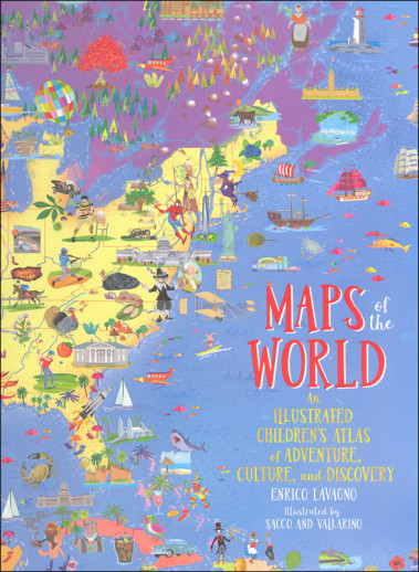
This resource equips young learners to take a virtual trip around the world with this unique atlas that combines maps, facts, and a little bit of seek-and-find fun. Each map is brightly colored and filled with icons that represent fun facts about that country. Students or teachers can also download additional free maps that include more detailed information. What new things will your students discover on their journey around the world? 136 pgs, h/c.
Publisher's Description of Maps of the World: An Illustrated Children's Atlas of Adventure, Culture, and Discovery
A lavishly illustrated, fact-filled, oversized atlas that allows children to discover the world without leaving their home.
Covering every continent, country, even outer space, MAPS OF THE WORLD is a vibrant and comprehensive atlas that children of all ages will love to explore.
The dozens of colorful, detailed maps are filled with charming, educational icons representing the aboriginal people in Australia, giant tortoises in the Galapagos, the Gold Rush in California, traditional dress in Mali, and even James Bond in England. Flip the next page in the book, and the corresponding icon key explains hundreds of these cultural, environmental, and societal illustrations. Organized by continent, the atlas also includes details on populations, language, agricultural, politics, and other bite-size facts.
Each map includes a link allowing kids to download a version of them on computers and tablets to explore even further. Captivating and comprehensive, MAPS OF THE WORLD will entice even the most reluctant young explorer.
Details
| Product Format: | Hardcover |
|---|---|
| Brand: | Black Dog and Leaventhal |
| Author: | Enrico Lavagno |
| Grades: | 1-5 |
| ISBN: | 9780316417709 |
| Length in Inches: | 11.75 |
| Width in Inches: | 9.375 |
| Height in Inches: | 0.75 |
| Weight in Pounds: | 2.2 |
Videos
Reviews