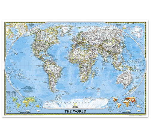
This classic world map is literally packed with information – ALL the important things you want to know! It’s laminated on both sides and has up-to-date international boundaries clearly defined. Thousands of place names are positioned carefully for best visibility to show all major bodies of water, cities & capitals, canals, airports, islands, and more. The shaded background shows valleys and labeled mountain ranges, and the inset maps show the north & south polar regions at the top and population density & vegetation/land at the bottom. Features an abbreviation key and lists largest countries by population and by area. Distortions are minimized on this map, so countries like Greenland are shown accurately. When studying the map for a longer time, use a magnifying glass to make the text super easy to read! Map scale is 1:37,213,000.
World Classic Map (Poster Size & Laminated) - 36"x24"
SKU
022206
ISBN
9781597752145
Grade 3-AD
These icons are designed to help you quickly understand and learn important information about our products.
Teaching Method
Traditional
Teacher-centered curriculum commonly used in classrooms that may include a text, teacher manual, tests, etc.
Charlotte Mason
A methodology based on the work of a 19th century educator who maintained that children learn best from literature (Living Books), not textbooks.
Classical
A methodology based on the Latin Trivium (three stages of learning), including the grammar stage (memorization and facts), logic stage (critical thinking), and rhetoric stage (developing/defending ideas).
Unit Study
A thematic or topical approach centered around one topic that integrates multiple subject areas.
Montessori (Discovery)
A methodology based on the work of a 20th century educator that emphasizes student and sensory-driven discovery learning and real-life applications.
Other
Other methodologies
Religious Content
Secular
Contains content contrary to common Christian beliefs (i.e. evolution).
Neutral
Avoids religious or theoretical topics or presents multiple viewpoints without preference.
Christian/Religious
Faith-based or including instructional religious content.
Learning Modality
Auditory
Learns through listening, talking out loud or reading out loud.
Visual
Learns through seeing, prefers written instructions and visual materials.
Kinesthetic/Tactile (Hands-On)
Learns through moving, doing and touching.
Multi-Sensory
Curriculum that employ a variety of activities/components.
Presentation
Sequential
Curriculum progresses through well-defined learning objectives. Emphasizes mastery before moving to the next topic.
Spiral
Topics and concepts are repeated from level to level, adding more depth at each pass and connecting with review.
Conceptual/Topical
Focus is on the “why,” often with a unifying concept as well as specific skills; coverage may be broader.
Teacher Involvement
Low Teacher Involvement
Student-led materials; parent acts as a facilitator.
Medium Teacher Involvement
A mix of teacher-led time and independent student work.
High Teacher Involvement
Teacher-led lessons; may utilize discussions, hands-on activities and working together.
Additional Materials Required
No other materials needed
Everything you need is included.
Other Materials Required
There are additional required resources that are a separate purchase.
Other Materials Optional
There are additional resources mentioned or recommended but are not absolutely necessary.
Consumable
Consumable
Designed to be written in; not reusable.
Non-Consumable
Not designed to be written in; reusable.
Our Price
$29.95 $29.95 $23.95
Rainbow Savings: $6.00
Product Overview
- Laminated, poster-size world map
- Packed with information!
- Distortions minimized
Description
Publisher's Description of World Classic Map (Poster Size & Laminated) - 36"x24"
Expertly researched and designed, National Geographic's World Wall Map
is the authoritative map of the world by which other reference maps are
measured. The 36" x 24" poster size supports easy and affordable framing and mounting, and takes less wall space than standard wall maps.
Category Description for Wall Maps U.S. & World
These 40"x 28" world and United States maps are perfect for any classroom. The U.S. map features state boundaries and capitals, while the world map displays the Mercator projection. It also includes an inset of Europe. NOTE: the world map 013434 does not include Palestine or Kosovo. Both of these maps come in full color and show time zones. Maps come rolled, in either paper or laminated versions. The Map Packs include one of each map. Now you just have to decide if you prefer paper or lamination. ~ Rachel S.
Details
| Product Format: | Other |
|---|---|
| Grades: | 3-AD |
| Brand: | National Geographic Maps |
| ISBN: | 9781597752145 |
| EAN/UPC: | 749717005235 |
| Length in Inches: | 32.125 |
| Width in Inches: | 1.1875 |
| Height in Inches: | 1.1875 |
| Weight in Pounds: | 0.95 |
Videos
Reviews