Children's Map of the World with New "Find then Answer" Feature
SKU
009153
ISBN
9780954840501
Grade PK-7
These icons are designed to help you quickly understand and learn important information about our products.
Teaching Method
Traditional
Teacher-centered curriculum commonly used in classrooms that may include a text, teacher manual, tests, etc.
Charlotte Mason
A methodology based on the work of a 19th century educator who maintained that children learn best from literature (Living Books), not textbooks.
Classical
A methodology based on the Latin Trivium (three stages of learning), including the grammar stage (memorization and facts), logic stage (critical thinking), and rhetoric stage (developing/defending ideas).
Unit Study
A thematic or topical approach centered around one topic that integrates multiple subject areas.
Montessori (Discovery)
A methodology based on the work of a 20th century educator that emphasizes student and sensory-driven discovery learning and real-life applications.
Other
Other methodologies
Religious Content
Secular
Contains content contrary to common Christian beliefs (i.e. evolution).
Neutral
Avoids religious or theoretical topics or presents multiple viewpoints without preference.
Christian/Religious
Faith-based or including instructional religious content.
Learning Modality
Auditory
Learns through listening, talking out loud or reading out loud.
Visual
Learns through seeing, prefers written instructions and visual materials.
Kinesthetic/Tactile (Hands-On)
Learns through moving, doing and touching.
Multi-Sensory
Curriculum that employ a variety of activities/components.
Presentation
Sequential
Curriculum progresses through well-defined learning objectives. Emphasizes mastery before moving to the next topic.
Spiral
Topics and concepts are repeated from level to level, adding more depth at each pass and connecting with review.
Conceptual/Topical
Focus is on the “why,” often with a unifying concept as well as specific skills; coverage may be broader.
Teacher Involvement
Low Teacher Involvement
Student-led materials; parent acts as a facilitator.
Medium Teacher Involvement
A mix of teacher-led time and independent student work.
High Teacher Involvement
Teacher-led lessons; may utilize discussions, hands-on activities and working together.
Additional Materials Required
No other materials needed
Everything you need is included.
Other Materials Required
There are additional required resources that are a separate purchase.
Other Materials Optional
There are additional resources mentioned or recommended but are not absolutely necessary.
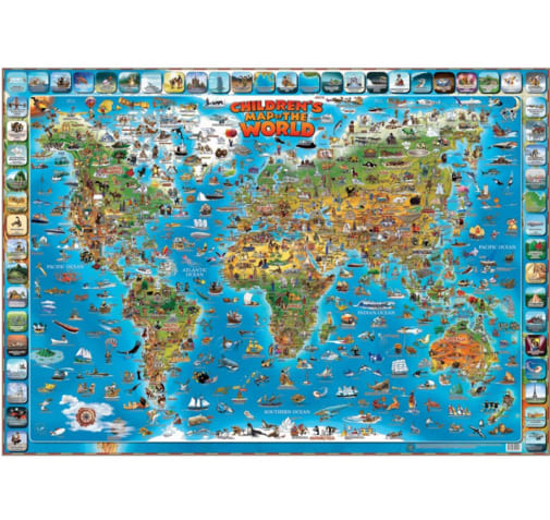
This laminated 54"x38" illustrative world map is not just your ordinary wall map. It contains geographical locations such as continents, countries, deserts, and bodies of water. Although it does not contain names of cities, there are illustrated pictures of famous events, well known landmarks, and examples of native people from each major country. The map is outlined with various questions related to geographical locations, which allows for fun and learning simultaneously. Some examples are as follows: “What is a Japanese traditional dish? - sushi." “Where do penguins live? - Antarctica." And, “Find the surfer. It's near the coast of Australia." Each question also has a picture demonstrating the answer. The vivid and relevant pictures, as well as the engaging questions are great for young visual learners!
Publisher's Description of Children's Map of the World with New "Find then Answer" Feature
This 38" x 54" laminated World map is loaded with hundreds of elements depicting points of interest such as historical facts, local interest items,cultural features, etc. With the 'Find Then Answer' feature, choose an image with it's question along the border of the map. Search the map for the image and answer the question. Answers are written upside down under the question. Each item in the map is individually labeled for ease of use.
These 40"x 28" world and United States maps are perfect for any classroom. The U.S. map features state boundaries and capitals, while the world map displays the Mercator projection. It also includes an inset of Europe. NOTE: the world map 013434 does not include Palestine or Kosovo. Both of these maps come in full color and show time zones. Maps come rolled, in either paper or laminated versions. The Map Packs include one of each map. Now you just have to decide if you prefer paper or lamination. ~ Rachel S.