We use cookies to make your experience better. To comply with the new e-Privacy directive, we need to ask for your consent to set the cookies. Learn more.
World Explorer Wall Map 32 x 20 - Flat Paper
SKU
047019
Grade PK-AD
These icons are designed to help you quickly understand and learn important information about our products.
Teaching Method
Traditional
Teacher-centered curriculum commonly used in classrooms that may include a text, teacher manual, tests, etc.
Charlotte Mason
A methodology based on the work of a 19th century educator who maintained that children learn best from literature (Living Books), not textbooks.
Classical
A methodology based on the Latin Trivium (three stages of learning), including the grammar stage (memorization and facts), logic stage (critical thinking), and rhetoric stage (developing/defending ideas).
Unit Study
A thematic or topical approach centered around one topic that integrates multiple subject areas.
Montessori (Discovery)
A methodology based on the work of a 20th century educator that emphasizes student and sensory-driven discovery learning and real-life applications.
Other
Other methodologies
Religious Content
Secular
Contains content contrary to common Christian beliefs (i.e. evolution).
Neutral
Avoids religious or theoretical topics or presents multiple viewpoints without preference.
Christian/Religious
Faith-based or including instructional religious content.
Learning Modality
Auditory
Learns through listening, talking out loud or reading out loud.
Visual
Learns through seeing, prefers written instructions and visual materials.
Kinesthetic/Tactile (Hands-On)
Learns through moving, doing and touching.
Multi-Sensory
Curriculum that employ a variety of activities/components.
Presentation
Sequential
Curriculum progresses through well-defined learning objectives. Emphasizes mastery before moving to the next topic.
Spiral
Topics and concepts are repeated from level to level, adding more depth at each pass and connecting with review.
Conceptual/Topical
Focus is on the “why,” often with a unifying concept as well as specific skills; coverage may be broader.
Teacher Involvement
Low Teacher Involvement
Student-led materials; parent acts as a facilitator.
Medium Teacher Involvement
A mix of teacher-led time and independent student work.
High Teacher Involvement
Teacher-led lessons; may utilize discussions, hands-on activities and working together.
Additional Materials Required
No other materials needed
Everything you need is included.
Other Materials Required
There are additional required resources that are a separate purchase.
Other Materials Optional
There are additional resources mentioned or recommended but are not absolutely necessary.
Consumable
Consumable
Designed to be written in; not reusable.
Non-Consumable
Not designed to be written in; reusable.
Our Price
$5.99 $5.99 $5.50
Rainbow Savings: $0.49
Description
Publisher's Description of World Explorer Wall Map 32 x 20 - Flat Paper
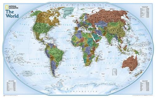
Expertly researched and designed, National Geographic's World Wall Map is the authoritative map of the world by which other reference maps are measured.
Product Features:
- Colorful Explorer style map with vibrant color palette that fills each country for easy identification
- Background shows mountain ranges and valleys in subtle shaded relief with mountain ranges labeled
- Major water bodies including rivers, lakes, glaciers, oceans, seas, gulfs, bays, straits, and bathymetry
- Clearly defined international boundaries, cities, islands, airports, and physical features
- Thousands of place names carefully and artfully placed to maintain legibility in heavily populated areas
- Up-to-date international boundaries and territorial control reflect de facto status on the ground
- Meticulously researched using multiple authoritative sources including the U.N., U.S. Board on Geographic Names, and policies of individual governments.
- Accurate place names use a combination of conventional English names, official national names, and standard transliterations for non-Latin alphabets.
- Drawn in Winkel Tripel projection with distortions minimized unlike other World maps (e.g. Greenland is shown the same size as Argentina, not South America)
- Corner inset charts list the largest cities by population and the largest countries by land mass and population.
Category Description for Explorer Wall Maps
National Geographic is a trusted name for maps, and it is exciting for us to offer them in our catalog. The explorer series of wall maps are all the same size - 32" x 20" - but in different scales for the world (1:51,969,000) and the US (1:6,107,000). Easy to use and visually appealing, these make perfect additions to any classroom wall. The world map is done in a Winkel Tripel Projection with the Meridian of Greenwich at the center of the map. All lines of longitude show the differences in time zones. Inset charts on the world map list the world's largest countries by area and population, and the largest urban areas by population. The US map is done in an Albers Conic Equal-Area Projection and includes insets of Alaska and Hawaii at the bottom of the map as well as interstates and major highways. Countries and states on both maps are attractively shaded in hues of green, brown, and purple, and most major cities and airports, lakes, rivers, and mountains are detailed. Maps come in three formats: flat (which are rolled and secured with a rubber band), tubed (a paper map supplied in a plastic storage tube), and laminated. - Zach
Details
| Product Format: | Other |
|---|---|
| Brand: | National Geographic Maps |
| Grades: | PK-AD |
| EAN/UPC: | 749717220898 |
| Length in Inches: | 25 |
| Width in Inches: | 2.25 |
| Height in Inches: | 2.25 |
| Weight in Pounds: | 0.65 |
Videos
Reviews