We use cookies to make your experience better. To comply with the new e-Privacy directive, we need to ask for your consent to set the cookies. Learn more.
Maps of the USA
SKU
028573
ISBN
9781557999559
Grade 1-6
These icons are designed to help you quickly understand and learn important information about our products.
Teaching Method
Traditional
Teacher-centered curriculum commonly used in classrooms that may include a text, teacher manual, tests, etc.
Charlotte Mason
A methodology based on the work of a 19th century educator who maintained that children learn best from literature (Living Books), not textbooks.
Classical
A methodology based on the Latin Trivium (three stages of learning), including the grammar stage (memorization and facts), logic stage (critical thinking), and rhetoric stage (developing/defending ideas).
Unit Study
A thematic or topical approach centered around one topic that integrates multiple subject areas.
Montessori (Discovery)
A methodology based on the work of a 20th century educator that emphasizes student and sensory-driven discovery learning and real-life applications.
Other
Other methodologies
Religious Content
Secular
Contains content contrary to common Christian beliefs (i.e. evolution).
Neutral
Avoids religious or theoretical topics or presents multiple viewpoints without preference.
Christian/Religious
Faith-based or including instructional religious content.
Learning Modality
Auditory
Learns through listening, talking out loud or reading out loud.
Visual
Learns through seeing, prefers written instructions and visual materials.
Kinesthetic/Tactile (Hands-On)
Learns through moving, doing and touching.
Multi-Sensory
Curriculum that employ a variety of activities/components.
Presentation
Sequential
Curriculum progresses through well-defined learning objectives. Emphasizes mastery before moving to the next topic.
Spiral
Topics and concepts are repeated from level to level, adding more depth at each pass and connecting with review.
Conceptual/Topical
Focus is on the “why,” often with a unifying concept as well as specific skills; coverage may be broader.
Teacher Involvement
Low Teacher Involvement
Student-led materials; parent acts as a facilitator.
Medium Teacher Involvement
A mix of teacher-led time and independent student work.
High Teacher Involvement
Teacher-led lessons; may utilize discussions, hands-on activities and working together.
Additional Materials Required
No other materials needed
Everything you need is included.
Other Materials Required
There are additional required resources that are a separate purchase.
Other Materials Optional
There are additional resources mentioned or recommended but are not absolutely necessary.
Consumable
Consumable
Designed to be written in; not reusable.
Non-Consumable
Not designed to be written in; reusable.
Our Price
$21.99 $21.99 $15.25
Rainbow Savings: $6.74
Description
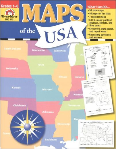
Maps of the USA introduces young students to each state in the U.S., along with details about each state and facts such as the state bird, flower, population, and area. The reproducible worksheets are pretty open-ended and can be used alongside any history program or state study to take a closer look at each state. The first hundred pages contain two-page spreads on each state, with state facts and black-and-white pictures to color on the left-hand side, and the state itself featured on the right-hand side. The right-hand page contains an outline map of the state itself, with geopolitical information, such as important cities, rivers, geographical features, and neat places to visit in that state. A smaller map of the U.S. is also provided with the featured state shaded in, so the student can see the location of the state in relation to the rest of the nation. These worksheets can be used to make a state notebook, or to use with any number of state activities, and can be colored, labeled, etc. Following the individual state pages are worksheets on the U.S. as a whole, including regions of the U.S. along with a segment of the map and questions for each, maps of the U.S. as a whole, both with and without state names filled in, a states and capitals chart, supplemental word puzzles, and maps featuring waterways, climate zones, and physical features of our nations along with questions for students to answer based on the map. "A U.S. State in Review" page is also included at the end, which can be reproduced and used alongside the individual state worksheets to fill in more facts about the state, draw its outline, and include in a state notebook, if they're making one. Answers included. - Jess
Publisher's Description of Maps of the USA
Maps of the USA has been updated and expanded! You’ll find geopolitical maps of each of the fifty states; political maps of the six regions; and political, physical, and thematic maps of the United States. You’ll also find fun facts, geography bee-type questions, and review pages.
The book is divided into four sections:
The Fifty States
- the state capital
- two most populous cities
- major rivers, mountains, and deserts
- and state borders
The Six Regions
- an outline map of the states in that region
- a small inset map of the United States with the region highlighted
- five questions about the region
- and a challenge research question
- 1 political reference map of the six regions of the United States
The United States
- the fifty states, labeled and blank maps
- mountains and deserts
- waterways
- climate zones
- time zones
- maps showing the location of the United States in North America and the World
- a study sheet that includes ten questions about the map and a challenge research question accompanies each map
Review
- a United States evaluation form
- a state evaluation form
- a crossword puzzle
- a word search
- and an answer key
Details
| Product Format: | Softcover Book |
|---|---|
| Brand: | Evan-Moor |
| Grades: | 1-6 |
| ISBN: | 9781557999559 |
| EAN/UPC: | 023472037213 |
| Length in Inches: | 11 |
| Width in Inches: | 8.5 |
| Height in Inches: | 0.5 |
| Weight in Pounds: | 0.8 |
Videos
Reviews