We use cookies to make your experience better. To comply with the new e-Privacy directive, we need to ask for your consent to set the cookies. Learn more.
Holy Land Relief Map "Then and Now" Laminated (19.5" x 26")
SKU
060048
ISBN
9781628621624
Grade 3-AD
These icons are designed to help you quickly understand and learn important information about our products.
Teaching Method
Traditional
Teacher-centered curriculum commonly used in classrooms that may include a text, teacher manual, tests, etc.
Charlotte Mason
A methodology based on the work of a 19th century educator who maintained that children learn best from literature (Living Books), not textbooks.
Classical
A methodology based on the Latin Trivium (three stages of learning), including the grammar stage (memorization and facts), logic stage (critical thinking), and rhetoric stage (developing/defending ideas).
Unit Study
A thematic or topical approach centered around one topic that integrates multiple subject areas.
Montessori (Discovery)
A methodology based on the work of a 20th century educator that emphasizes student and sensory-driven discovery learning and real-life applications.
Other
Other methodologies
Religious Content
Secular
Contains content contrary to common Christian beliefs (i.e. evolution).
Neutral
Avoids religious or theoretical topics or presents multiple viewpoints without preference.
Christian/Religious
Faith-based or including instructional religious content.
Learning Modality
Auditory
Learns through listening, talking out loud or reading out loud.
Visual
Learns through seeing, prefers written instructions and visual materials.
Kinesthetic/Tactile (Hands-On)
Learns through moving, doing and touching.
Multi-Sensory
Curriculum that employ a variety of activities/components.
Presentation
Sequential
Curriculum progresses through well-defined learning objectives. Emphasizes mastery before moving to the next topic.
Spiral
Topics and concepts are repeated from level to level, adding more depth at each pass and connecting with review.
Conceptual/Topical
Focus is on the “why,” often with a unifying concept as well as specific skills; coverage may be broader.
Teacher Involvement
Low Teacher Involvement
Student-led materials; parent acts as a facilitator.
Medium Teacher Involvement
A mix of teacher-led time and independent student work.
High Teacher Involvement
Teacher-led lessons; may utilize discussions, hands-on activities and working together.
Additional Materials Required
No other materials needed
Everything you need is included.
Other Materials Required
There are additional required resources that are a separate purchase.
Other Materials Optional
There are additional resources mentioned or recommended but are not absolutely necessary.
Consumable
Consumable
Designed to be written in; not reusable.
Non-Consumable
Not designed to be written in; reusable.
Our Price
$14.99 $14.99 $10.95
Rainbow Savings: $4.04
Description
Publisher's Description of Holy Land Relief Map "Then and Now" Laminated (19.5" x 26")
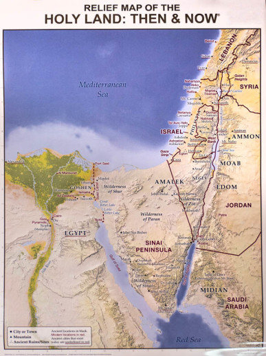
Easily see where Bible places are located today with its red "Then and Now" boundary linesand enjoy its stunning detailed relief of the Holy Land's mountains, valleys, rivers, deserts, and more. Perfect for Bible studies, Sunday school lessons, homeschool curriculum, and to display in your classroom, church hallway, or office.
Usually, the information included on this Bible map is shown on two separate mapbut for the first time ever Rose has combined this useful information onto one Bible wall map. Red print shows the major cities and boundaries of modern countries. Laminated for durability. Write on it with water soluble markers and easily wipe marks off. Size: 19.5" x 26", heavy chart paper.
Category Description for Bible Lands Relief Maps - Laminated
Rose Publishing has a reputation for producing quality Bible resources, like Then & Now Bible Maps. They have now published wall maps of the same great quality. The maps measure 19.5" x 26" and are laminated so you can write on/wipe off with water soluble markers. These are relief maps of the Middle East and the Holy Land, and the amazing details show mountains, mountain ranges, rivers, cities, towns, ancient ruins, and more. Modern locations are printed in red and ancient cities that are still in existence are underlined in red.
The back of each map has 4 reproducible worksheets related to the content of the map. The 7 1/2" x 10" worksheets on the reverse of the Holy Land map are black and white and include a present day (Now) map of the Holy Land, a map of what the Holy Land once looked like (Then), and two sheets that list Holy Land archeological sites. The Middle East map offers Then and Now black and white maps of the Middle East to reproduce along with two reference sheets for the Middle East and Scripture. These maps are beautiful and helpful when studying ancient history and/or the Bible. ~ Donna
Details
| Product Format: | Other |
|---|---|
| Brand: | Rose Publishing |
| Grades: | 3-AD |
| ISBN: | 9781628621624 |
| Length in Inches: | 28 |
| Width in Inches: | 19.375 |
| Height in Inches: | 0.0625 |
| Weight in Pounds: | 0.2813 |
Videos
Reviews